Some of the most widely used datasets in DataShare are the collections of photographs of tower blocks and mass housing, both in the UK and internationally, created by Miles Glendinning, Professor of Architectural Conservation in the Edinburgh School of Architecture and Landscape Architecture (ESALA). Recently, Miles deposited a number of new datasets to the DOCOMOMO International Mass Housing Archive collection, including recent research data-gathering exercises in Belgium, China, Chile, Italy and Morocco. Further to this, are two archives of photos documenting Berlin in the 1980’s. Covering both East and West Berlin, these images provide striking visual representations of the buildings, transport infrastructure and general urban environment of the time, revealing a fascinating glimpse into the DDR (Deutsche Demokratische Republik), the BRD (Bundesrepublik Deutschland) and the enforced division between them.
To help shine a light on this special set of images, I asked Miles to answer three questions regarding the creation of this dataset.
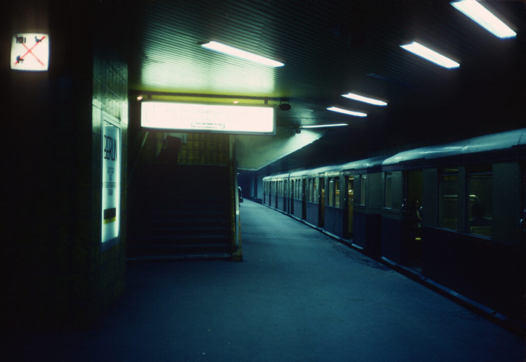
Mitte – Friedrichstrasse. (Nord-Sud S-Bahn), Sept 1982 Photo credit: Miles Glendinning https://doi.org/10.7488/ds/8062
1 – What drew you to Berlin during this period?
I was drawn to visit East and West Berlin in 1982 by a curiosity to see first-hand what the Wall was like in its ‘mature’ state, and to experience, however briefly, the contrasting ways of life in the two parts of the city – East Berlin a would-be capital city with an alien entity adjoining its city core, and West Berlin a somewhat peaceful, even backwater-like island city-state divorced from the mainstream hubbub of West German life: at that stage, in the pre-Gorbachev era, there was no suspicion that the Iron Curtain only had a few more years of life, and the situation all seemed irreversibly settled in a strange sort of stagnant air immobility.
What particularly interested me were the quirky anomalies thrown up by the makeshift character of the division-line, including strange ‘exclaves’ such as Steinstücken – a few houses accessible by its own bus route through a narrow extrusion in the Wall), and the strange status of the S-Bahn (the local suburban rail network), whose lines in West Berlin were run indirectly by the DDR authorities, and had fallen into seemingly terminal decay and dereliction following many years of boycotts by West Berliners.
Several S-Bahn stations also featured bizarre border anomalies, such as the ‘door in the Wall’ that gave access to Wollankstraße station, and the underground/overground West-Berlin interchange and border crossing in the centre of East Berlin at Friedrichstraße.
Other infrastructural monuments of division and decay included the enormous DDR customs checkpoints complex newly built just north of ‘Checkpoint Charlie’, and later demolished immediately in 1990, or the disused Olympic Stadium bequeathed by the Nazi regime.
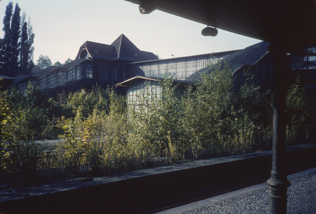
Wedding – Bf Gesundbrunnen – Sept 1982 view A – Photo credit: Miles Glendinning https://doi.org/10.7488/ds/8063
2 – Your images are documented with metadata of where they were taken, but beyond that, does looking at any of the photos bring back any particular memories?
The strongest memory brought back by looking at the photos is the sense of ‘suspended animation’ that was pervasive throughout the city, with some bustle in the ‘Ku’damm’ and ‘Alex’, but significant areas of dereliction and disuse everywhere, especially near the border, plus stereotypical ‘communist greyness’ throughout East Berlin, and a general feeling of relative lack of population and urban energy in both halves of the city.
The images of quiet decay and dereliction seem to evoke feelings akin to the ‘deploratio urbis’, or lamentation for lost greatness, felt by Renaissance and Romantic visitors among the ruins of classical Rome: looking at a 1982 photo such as that of the spectacularly overgrown wasteland of Gesundbrunnen station, what one saw was a vista of apparently irreversible decay, with no hint of the spectacular reversal that lay only a decade ahead.
From a modernist heritage perspective, however, many of the structures built during the division today seem of growing historical interest, including West-Berlin’s outer modern social housing complexes such as the Märkisches Viertel, or the extensive ‘Plattenbau’ complexes ubiquitous throughout East Berlin (on which see also the more recent images in the Docomomo International Mass Housing Archive, https://datashare.ed.ac.uk/handle/10283/2927 ).
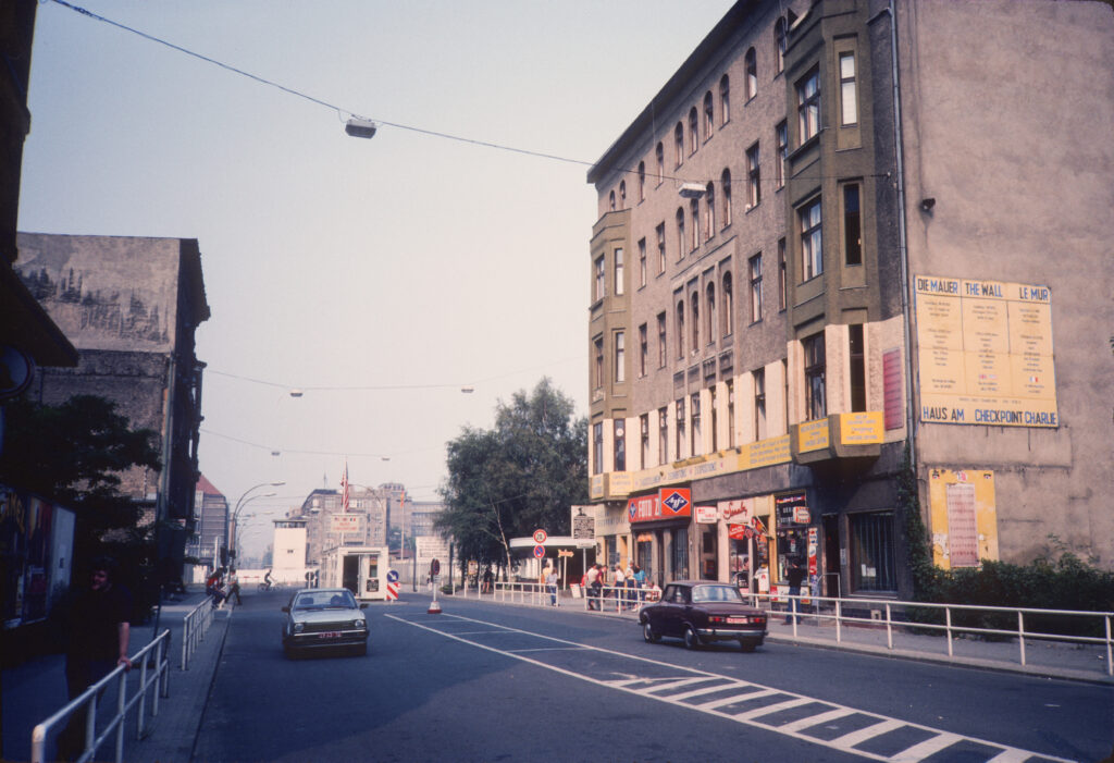
Kreuzberg – Friedrichstrasse, Checkpoint Charlie, Sept 1982 Photo credit: Miles Glendinning https://doi.org/10.7488/ds/8063
3 – How do you envisage the images in the dataset being used?
As always, it’s rather difficult to predict the very varied ways in which images such as these could be used, but I imagine that they could be useful for scholarly exploitation by historians of 20th-century Germany or of its post-war built environments, or as a more popular level, by enthusiasts for ‘Cold War heritage’ or ‘Ostalgie’?
Many thanks to Miles for taking the time to respond so insightfully to the questions.
The items containing the Berlin photos can be found at the following links:
The wider collections of tower blocks in the UK and mass housing internationally can be found at:
DOCOMOMO International Mass Housing Archive
Keith Munro,
Research Data Support Assistant