Home University of Edinburgh Library Essentials
May 8, 2026
APCs paid in the wild
As part of the Lessons in Open Access Compliance for Higher Education (LOCH) project we have been looking at the problems of identifying Article Processing Charges (APCs) that the Library is not currently aware of – which we colloquially call ‘APCs paid in the wild’. We have written a short case study that is currently under open review at The Winnower:
Improving estimates of the total cost of publication by recognising ‘APCs paid in the wild’
The take home message from our ‘APCs paid in the wild’ case study can be summarised as:
We estimate that these costs could account for up to 20% extra in the total cost of publication that is not currently being accounted for. This additional cost is important to take into account when institutions are negotiating fair offsetting agreements for open access publishing.
We would welcome any constructive criticism on the work so please have a read and leave an open review so that we can improve the article.
Boxing Clever
Rehousing is a key part of conservation. But why is it so important? Find out in this week’s blog from Special Collections Conservator, Emily…
We recently received a large number of drop spine boxes to house the Laing Western manuscript collection. This was a part of a month-long project to conserve this collection, which you can read more about by following this link. These boxes are handmade to match the exact dimensions of the book. Not only do they look great on the shelves, they also provide excellent protection for the books. However, they are relatively expensive and time consuming to make. So the creation of these boxes is often outsourced, and reserved for our most important collections.

Laing manuscript collection, before rehousing

Laing manuscript collection, after rehousing
Time to relax
The time to relax is when you don’t have time for it
Sydney J. Harris
Revision week is well underway and the library is getting busier and busier. Libraries are great places to study, offering a quiet, calm space to work. The Main Library is even offering extra study spaces for students during this time.
However, we have more to offer than study spaces! As part of our ongoing campaign to help students, we have been offering free hand massages today!

We hope that everyone who received a massage really benefited from it, but if you missed out, never fear! We have set up a Relaxation Table in the Main Foyer, which will be around for the next few weeks, offering fun activities such as origami, puzzles, and colouring. Remember, it is important to take breaks to stay focussed! There will also be aromatherapy, bubble wrap, and relaxing herbal tea for students to take away, among other things. Don’t miss out, and make sure to Tweet or Facebook us your thoughts and creations (#happylibrary)!

Also, watch out for us on Friday, when we will be celebrating Shakespeare’s 400th birthday and World Book Night! Follow us on Facebook and Twitter for more details.
To get you in the party mood, here’s an image of Shakespeare from our collections:
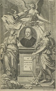
Title page of The Works of Mr William Shakespeare, Vol.1, 1709. S*.30.1. © The University of Edinburgh. See it here.
Remember, we have more than just textbooks and study spaces! Happy studying!
Trial access to ClinicalKey

We are trialling access to Elsevier’s ClinicalKey database until 22nd December 2016.
ClinicalKey is a clinical search engine that helps health professionals make decisions anywhere, anytime, in any patient scenario. ClinicalKey’s Smart Search saves time by preventing unnecessary extra searches. Look up “myocardial infarction,” for example, and Smart Search recognizes its acronyms, synonyms, related surgical procedures and drugs, as well as the fact that it’s a cardiovascular disease associated with high cholesterol.

ClinicalKey allows you to access the latest (indexed daily), most evidence-based answers in every medical and surgical speciality. It contains:
- 1400+ Topic Pages
- 1000+ full-text reference books
- 600+ full-text journals
- 17,000+ medical and surgical videos
- 300+ Procedures Consult videos and articles
- 2,200,000 images
- 50+ Clinics
- 850+ First Consult monographs
- 2,900+ drug monographs
- 4,500 practice guidelines
- 15,000 customisable patient education handouts
- Fully indexed Medline
- Clinical trials from the ClinicalTrials.gov database
- See the full list of content at http://elsevierresources.com/clinicalkey/files/2016/04/Master_Content_List.xls.
See the ClinicalKey overview video below…
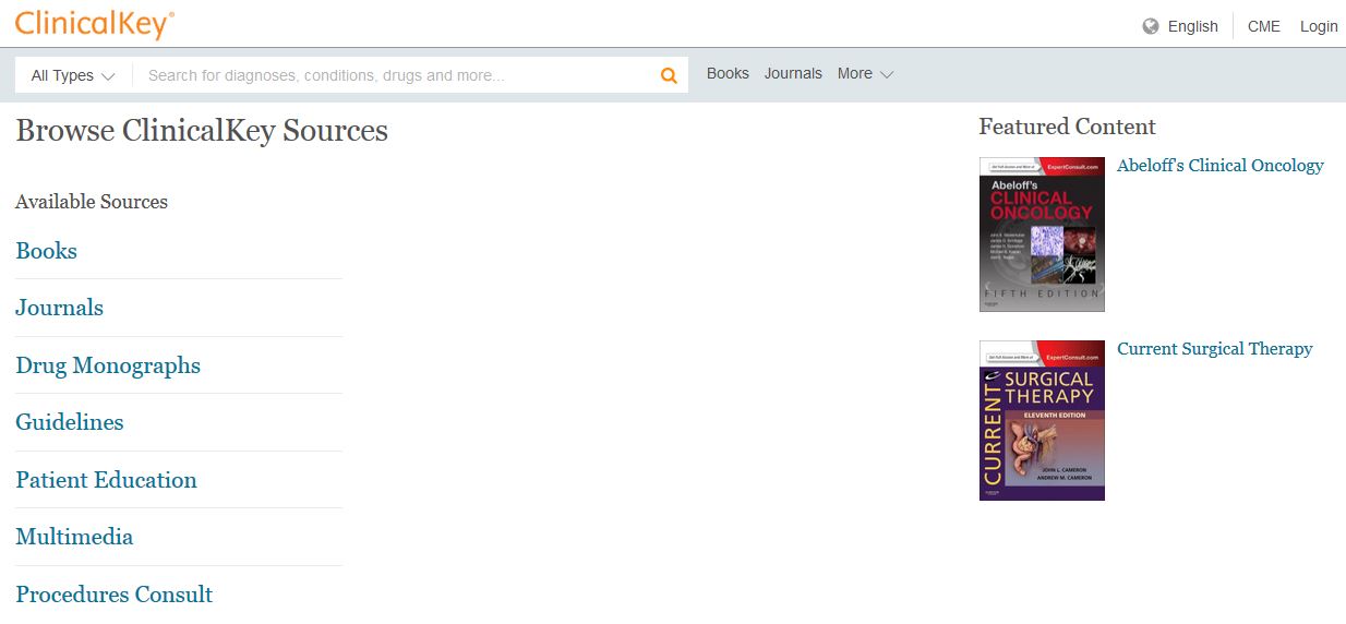
Browse the e-resources on ClinicalKey
Further information
More information about ClinicalKey can be found at https://www.clinicalkey.com/info/uk/how-clinicalkey-works/ and a complete userguide is available at https://www.clinicalkey.com/info/uk/wp-content/uploads/sites/15/2014/09/CK_UserGuide_Version2.0.pdf
Further video guides on the Topic Pages, Filters and Presentation Maker available at https://elsevierresources.com/clinicalkey/clinicalkey/trial-resources/
Log in for more personalised content – Interested in trying out the CME area, presentation maker area or saving search histories? Select Login, then “Other Institution Login”, then “UK Access Management Federation” from the drop down menu and then click on University of Edinburgh and then select ClinicalKey from the menu and then the Library link. You’ll now enter your EASE login and CME credits will be logged.
Access ClinicalKey on or off campus via the E-Resources Trials webpage or DiscoverED. Please fill out the trial feedback form with your comments on this trial and whether you would like the library to subscribe.

Additional study space in the Central area
There is a wide range of study space available across the University, full details of which – completely with interactive map – may be checked here.
However, as the exam period approaches, additional space has now been made available.
Milestone marked with musical twist

Musical instruments from the University’s world–class collection heralded the half-way point in St Cecilia’s £6.5million renovation.
The musical curiosities were played at a ‘topping out’ ceremony – traditionally held by construction workers – to celebrate progress in the restoration of St Cecilia’s Hall.
Construction workers, University students, staff and project supporters gathered on site for a unique acoustic recital of a 19th century contrabass serpent, performed by musician Tony George.
The copper serpent played dates from around 1815 and was made in Glasgow. It is a descendent of the cornet and a distant ancestor of the tuba. The unusual instrument gets its name from its long cone, which is bent into a snake-like shape.
A 19th century ophicleide – an early predecessor of the tuba – was also played at the event.
Jacky MacBeath, Head of Museums at the University of Edinburgh, said: “The topping out ceremony was a wonderful opportunity to celebrate reaching a landmark moment in St Cecilia’s Hall’s renovation.
“The performance was a fitting tribute for the project and gave our students, partners and contractors the chance to experience some of the world’s finest instruments that will be on public display in the near future.”
The Adventure Begins…
Science, freedom, beauty, adventure: what more could you ask of life? Aviation combined all the elements I loved.
Charles A. Lindbergh, The Spirit of St. Louis

A model, with some wings, in the Playfair Library…. No, it’s not a new version of Cluedo, it’s this year’s University of Edinburgh’s Festival of Museums photoshoot!
With only a month to go until our One Last Adventure Festival of Museums weekend (13th-15th May), the adventurous times have begun with an action-packed aviation-inspired photoshoot with the fantastic Laurence Winram!

Fuelled by tea and coffee and with the model, Graham, dressed as an early aviation pioneer (complete with goggles and a pipe!), Laurence and his team worked tirelessly to get the perfect ‘adventurous’ shot in the wonderful setting of the University’s Playfair Library.
We can’t wait to see the results but in the meantime, if you fancy an adventure of your own, registration for all our events is now open https://onelastadventureuoe.wordpress.com/ – pirates, treasure, anatomy and bugs (yes really!) await so…
Let us step into the night and pursue that flighty temptress, adventure.
J.K. Rowling, Harry Potter and the Half-Blood Prince
Just breathe
As part of our ongoing mission this term to let students know we care, we have been using some essential oils to help students relax today!
Aromatherapy has been around for a long time, for example in China and Egypt, where oil and incense have been used for up to 6000 years. A recent study by Lee Redstone, published by the Archives of Psychiatric Nursing, has shown that essential oils can enhance mindfulness therapy by reducing stress and anxiety levels.
We hope that students felt the effects of our soothing blend of Lavender and Eucalyptus oil today – hopefully they had more luck smelling it than this statue from our collections would!

Gandharan sculpture fragment: Head of Buddha, 1st century, EU1343. See it here.
We will be popping up regularly next week during revision time and in the exam period following that. We have organised some very exciting events to help students relax, and also plan to celebrate a certain someone’s very special 400th birthday, so keep an eye on Facebook and Twitter! Also look out for our table in the Main Library Foyer, which will have aromatherapy as well as mindfulness activities for students to try!
Remember, your library loves you!
Classical and Ancient Near Eastern Studies 2015
The Library has recently purchased access to the e-book collection Classical and Ancient Near Eastern Studies 2015 from the publishers DeGruyter, which gives us access to over 80 titles from 2015.

All of the e-books from the collection can be accessed individually via DiscoverEd.
DeGruyter is one of the leading scholarly publishers in Classical Studies and their Classical and Ancient Near Easter Studies 2015 collection of text corpora and reference works covers the history and culture of the ancient Mediterranean, Near East and Egypt in all their aspects. Read More
When is a hill a hill? Mapping, “occular inspection” and the problem of standardisation in Robert Douglas’s General View of the Agriculture in the Counties of Roxburgh and Selkirk
In October 1795, Sir John Sinclair asked Rev. Robert Douglas of Galashiels to “assist the Board of Agriculture” by updating and republishing the County Surveys of Roxburghshire and Selkirkshire. Sinclair had been frustrated at the eccentric diversity of styles employed by the various contributors to the first phase of the Statistical Account, and he now sought to standardise according to the model of his favourite: the Midlothian survey. He hoped that Douglas would contribute his local knowledge to a national statistical survey, by copying the format, structure, and style of a prototype. However, the production of this survey, and in particular the production of the map it contained, illustrates just how challenging such standardisation could be.

Map of Roxburghshire, from the General View of the Agriculture in the Counties of Roxburgh and Selkirk (1798). Photo by the author.
By January 1798, Douglas’s reports were completed and published, alongside a map of each county, in a single volume: General View of the Agriculture in the Counties of Roxburgh and Selkirk, with Observations on the Means of Their Improvement. To produce the maps, Douglas engaged the professional assistance of the Edinburgh-based mapmaker John Ainslie. Ainslie has been called “virtually the Master-General of Scotland’s national survey”. He was employed to prepare maps of a number of Scotland’s southern counties, at the indirect behest of Sinclair, to illustrate the various Surveys in the late 1790s. In some cases, where the county had already been surveyed in recent decades, Ainslie’s task was merely to copy pre-existing maps. In the case of Roxburghshire, Ainslie used a pantographer to reduce Matthew Stobie’s 1770 map of the county. Ainslie wrote to Douglas in May 1797:
I have perused the coloured map of the County [of Roxburghshire] and has [sic] begun Engraving a new Plate by reducing Stobies map exactly and have put in the villages and Towns from the map you sent onto me. I am at the greatest loss about the Hills. You complain of them being too dark, if I had done them for another county they would have been reckoned too light. I am doing the County of Kirkudbright just now and the people concern’d about it finds great fault because the hills are not dark enough altho much bolder than your map they have actually given me orders to make every one of them stronger before I get them done as they want they will be very dark indeed.
So Ainslie had trouble standardising the topographical features on his county maps, as he found that different counties’ hills required different treatment. In the same letter he refers to the map of Selkirkshire as “totally hills which is the most tedious of all engraving”.
In the preface of his General View, Douglas felt obliged to explain the different cartographic rationales that informed the maps of Roxburghshire and Selkirkshire:
In that [map] of Roxburghshire, nothing is inserted, but the names of parishes, towns, villages, such places as are mentioned in the work, and a few on the confines which jut out into other counties. With regard to Selkirkshire, there being few parish churches or villages, and not many farms deserving particular notice in an agricultural view, had the same rule been rigidly followed, a large track of it would have appeared uninhabited; to prevent which, the seats of the residing proprietors, the places from whence others take their titles, and some of the most extensive farms, are named in the map
In some cases, the imperfect science of hill-mapping led to debates about a hill’s very existence. Douglas had sought advice about possible “alterations and additions” to Ainslie’s draft map of Roxburghshire. He sent a manuscript copy to a number of correspondents, who took it out into the field to test its accuracy. James Arkle, minister for Castletown in the southern tip of Roxburghshire, wrote to Douglas with his own opinions on Ainslie’s map:
I received yours with the Map of the County inclosed which I now return and shall with pleasure give such answers to your enquiries as my information enables me… I have… carried the map along with me thro’ the parish and have compared it with the real situation of the Country by occular [sic] inspection. The line is drawn with ink separating the moor from the green pasture as accurately as possible. We are not of Mr Olivers opinion as to the nonexistence of the hill he has crossed. It lies between Thorlishope and Peel, tho’ not high when compared with the others near it, yet it rises to a considerable height. I cannot say that I am able to mark the hills by name as they appear on your map. If you have a copy of Stobies Map of County, I believe they are distinctly pointed out on it.
“Mr Oliver” had been given first look at Ainslie’s map, which was a reduced version of Stobie’s, and had crossed out a hill. Clearly Arkle disagreed with his assessment, on the basis of his own subjective “occular inspection.” The hill in question lay northeast of Thorlishope, and is represented by a faint fingerprint-like symbol on Stobie’s map.

Detail from Matthew Stobie’s Map of Roxburghshire or Tiviotdale (1770). The hill in question is the section of shading north of Thorlishope. Image: NLS.
It is absent from the map ultimately published with Douglas’s General View, whereas the nearby hills northwest of Dawstane are clearly defined on it. It was not until later in the nineteenth century that the Ordnance Survey used contours to standardise hill-sketching.
In the meantime, the status and depiction of hills varied from map to map, depending on the criteria and propensities of the mapmaker(s), or on the subjective “occular inspection” of a chain of informants. This meant that, on the maps of the Statistical Account, a hill of a certain height in one county was not necessarily a hill in another. Therefore, Sinclair’s desire for standardised surveys according to one archetypical model was necessarily thwarted.
Philip Dodds, School of Geosciences University of Edinburgh
Twitter: @PA_Dodds
We hope you have enjoyed this post: it is characteristic of the rich historical material available within the ‘Related Resources’ section of the Statistical Accounts of Scotland service. Featuring essays, maps, illustrations, correspondence, biographies of compliers, and information about Sir John Sinclair’s other works, the service provides extensive historical and bibliographical detail to supplement our full-text searchable collection of the ‘Old’ and ‘New’ Statistical Accounts.
Sources
Robert Douglas’s correspondence, quoted here, is in the National Library of Scotland: MS.3117.
Collections
 Hill and Adamson Collection: an insight into Edinburgh’s past
My name is Phoebe Kirkland, I am an MSc East Asian Studies student, and for...
Cataloguing the private papers of Archibald Hunter Campbell: A Journey Through Correspondence
My name is Pauline Vincent, I am a student in my last year of a...
Hill and Adamson Collection: an insight into Edinburgh’s past
My name is Phoebe Kirkland, I am an MSc East Asian Studies student, and for...
Cataloguing the private papers of Archibald Hunter Campbell: A Journey Through Correspondence
My name is Pauline Vincent, I am a student in my last year of a...
Projects
Cataloguing the private papers of Archibald Hunter Campbell: A Journey Through Correspondence
My name is Pauline Vincent, I am a student in my last year of a...
Archival Provenance Research Project: Lishan’s Experience
Presentation My name is Lishan Zou, I am a fourth year History and Politics student....