My name is Denise Hick and I am a Master’s student in Earth Observation and Geoinformation Management at the University of Edinburgh. Together with Rowan Rush-Morgan, a second-year PhD student in Geography, we had the opportunity of working on an exciting web-mapping internship for the Regional Ethnology of Scotland Project (RESP) within the Centre for Research Collections (CRC).
A web-map was envisaged as an interactive way for users to browse the RESP catalogue in a visual way, finding recordings based on the place names mentioned within them. There are some examples of using web-mapping technology to visualise archival information, such as this map (https://witches.is.ed.ac.uk/ ) of witch trials in Scotland. However, we could not find any examples that used data directly from within an archival catalogue, so this would be a venture into the unknown both for ourselves and the RESP team.
Geocoding and updating the Archive
Throughout the internship, Rowan focused on data preparation. Place names were collated from recording transcripts, these were then converted into co-ordinates using the QGIS Geocode plugin. This was no easy task: in fact, multiple places with the same name exist. You can find Aberdeen in Hong Kong, the USA, and Jamaica! Furthermore, interviewees often refer to places by their locally known rather than ‘official’ names, while other place names have changed over the years. After finding the best possible co-ordinate matches, Rowan added this information to ArchivesSpace, RESP’s digital archive, linking each place name to the interview where it was mentioned.
Pins on the map
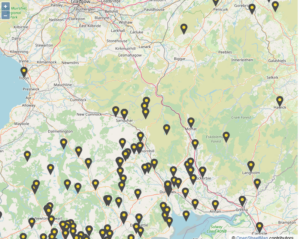
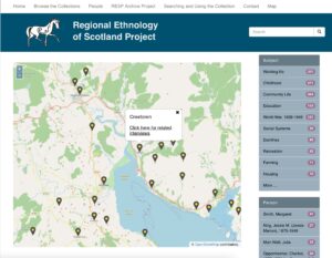
While Rowan prepared the data, I focused on setting up the web map. With the help of Scott Renton, IT project manager, and Patryk Smacki, software developer at the University of Edinburgh, we developed an interactive web map for the RESP website using open-source mapping library OpenLayers. This entailed a lot of coding in JavaScript and Python. To improve performance, we then had to come up with an innovative way of plotting the place name data onto the map in the form of clickable pins, because the RESP archive now contains more than 300 different place names!
The end result
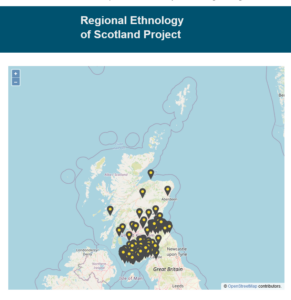
The final result of our internship is an interactive web map that displays places mentioned in the interviews carried out by RESP in Dumfries and Galloway and East Lothian (consultable here). Users can explore the map and zoom, pan and click on a pin to be directed to all the RESP interviews relating to that specific place. We hope the map gives users a much more accessible way to browse the RESP catalogue and offers an example to other archives of the ways in which web-mapping technologies can be utilised to visualise archival collections.
We have really enjoyed our time with the RESP team. Whilst at times challenging, it has been an interesting internship and we learnt a lot about geocoding and coding, but also about Scottish geography, life and traditions!